From the Ground Up: NASA Harvest and Kenyan Partners Lay Foundation for Crop Yield Insights
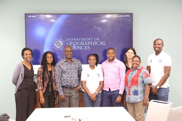
Participants from the July 2023 ECAAS workshop hosted by NASA Harvest at the University of Maryland. Pictured left to right: Dr. Catherine Nakalembe, UMD; Diana Frimpong, UMD; Kennedy Anahinga, Kenya Ministry of Agriculture; Esther Maina, Kenya Space Agency; John Juma Katana, Kenya Ministry of Agriculture; Taryn Devereux, UMD; Jane Kioko, Kenya Ministry of Agriculture; Peter Okello, Kenya Space Agency.
Across East and Southern Africa, there persists a critical gap in available crop analytics - specifically, a lack of robust and readily available field data collection to support model development, evaluation, and validation. This gap exists because most countries in Sub-Saharan Africa do not conduct consistent and timely yield assessments. Additionally, data from typical agricultural censuses is rarely directly usable for crop-yield estimation and evaluating remotely sensed or derived yield estimates.
In support of AGRA’s Regional Food Balance Sheet (RFBS), the NASA Harvest team at the University of Maryland (UMD) is developing a regional yield sampling framework for evaluating and building a consistent ground dataset for regional yield assessment. This new project, “Developing a Framework for Regional Yield Data Collection,” is supported by the Enabling Crop Analytics at Scale (ECAAS) initiative and builds off the success and lessons learned from NASA Harvest’s ECAAS Phase-1 project.
In July 2023, the NASA Harvest team hosted a week-long workshop with key project partners - the Kenya Ministry of Agriculture (MoA) and the Kenya Space Agency (KSA). The goals of this collaborative event were to review the sampling frame design and develop a field campaign to collect maize yield data for the upcoming harvest season and discuss long-term, sustainable data collection and utilization.
ECAAS Phase-1
In 2022, UMD implemented a project funded by the Enabling Crop Analytics at Scale (ECAAS) in Katavi, Tanzania. This project, called "Optimizing Crop Yield Data Collection for Supply Chain Enhancement," aimed to test the scalability of collecting rice paddy yield data using the OpenDataKit toolkit. Field agents used the ECAAS toolkit to collect field boundary and other farm data. They gathered information from over 800 paddy fields and followed up to collect yield data from more than 600 farms after harvest. The first project demonstrated the success of leveraging low-cost digital tools to efficiently collect yield data in collaboration with smallholder farmers [Link to report on Phase-1 outcomes]. The NASA Harvest team is working with data collected during phase one to develop and apply a scalable field scale yield assessment framework.
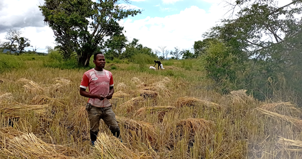
Field enumerators returned to farms at the day of harvest to capture rice yield data as part of the ECAAS Phase-1 project in Tanzania.
A new round of work under ECAAS aims to build on the following key learnings from Phase-1:
- Early involvement of the Ministry of Agriculture in design and planning to ensure alignment with their monitoring programs and needs. This facilitates institutionalization and sustainability.
- Developing the sampling frame with sufficient lead time to guide data collection.
- Leveraging county extension agents for data collection, as they have local knowledge and connections with farmers.
- Hands-on engagement by the UMD team in field training and data collection to transfer skills.
- Using Kenya as a model case to inform the development of sampling frameworks in other focus countries.
From July 24-28, 2023, NASA Harvest hosted a collaborative workshop at the University of Maryland. Key participants included representatives from the Kenya Ministry of Agriculture (MoA) and the Kenya Space Agency (KSA). The goals of the week-long workshop were to assess lessons learned from ECAAS Phase-I in Tanzania, understand national and regional data collection approaches, and identify opportunities to integrate the ECAAS initiative with partner institutions for sustained data utilization.
The UMD NASA Harvest program team was led by Dr. Catherine Nakalembe, with support from Ms. Taryn Devereux, Ms. Diana Botchway Frimpong, Mr. Adebowale Adebayo, and Ms. Isha Asalla. Participants included Ms. Jane Kioko and Mr. John Juma Katana from the Kenya MoA; Mr. Kennedy Ogora from the MoA Crop Insurance Programme; and Mr. Peter Okello and Ms. Esther Maina from KSA. Also in attendance was Mr. Kenneth Mwangi (ICPAC).
Guests included Dr. Christopher Justice, Chief Scientist for NASA Harvest, and Mr. John Keniston, UMD Senior Faculty Specialist and GIS Specialist for NASA Harvest. Dr. Garik Gutman from NASA Land Cover and Land Use Change (LCLUC) also gave a guest presentation on the program.
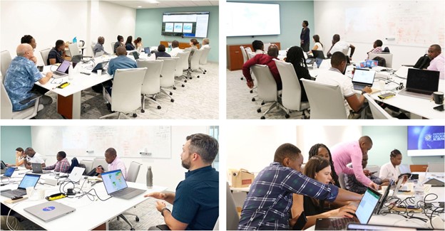
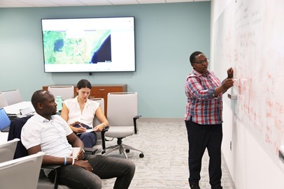
Caption: Left: Dr. Garik Gutman, Director of the NASA LCLUC, program gives an overview of the program and the online platforms available to different end users. Right: Data collection scheduling working session: Botton: John Keniston leading an overview of GLAM 2.0
The workshop opened with presentations and discussions assessing lessons from ECAAS Phase-1 in Tanzania, to identify opportunities for institutional integration moving forward. Key topics included finalizing the project timeline and Kenya sampling frame developed by the NASA Harvest team. The group also established data collection methods and fieldwork protocol for the upcoming maize yield data campaign. The resulting data will support the development and evaluation of the 2022 maize yield map and estimates.
Doctoral student Adebowale Adebayo led the sampling frame design process. He presented the framework methodology and stratification approach early in the week, facilitating discussions on optimal design protocols with MoA and KSA partners. The sampling framework aimed to accurately characterize cropland distribution and phenology, while also optimizing the efficiency of the field data collection campaign.
The beginning of the week focused on several presentations and discussions around the ECAAS project and assessing lessons learned from ECAAS Phase-1 in Tanzania as a lead-in to identify points of institutional integration. Key discussion points centered around the ECASS project and timelines, including the Kenya sampling frame developed by the NASA Harvest team and establishing data collection methods and fieldwork protocol for the upcoming field campaign. The resulting data from this campaign will be used to develop and evaluate the 2022 maize map and yield estimates.
The UMD team led sessions on using Collect Earth Online for sampling frame labeling and validation. By labeling selected blocks, the field campaign can more efficiently focus on areas with a high prevalence of crop fields.
MoA, crop insurance, and KSA partners also gave presentations on their institutions' use of Earth observation data for food security monitoring. This allowed for the assessment of available datasets and tools to integrate with ECAAS.
Toward the workshop close, the group finalized a collaborative fieldwork plan for the maize data collection campaign. County extension agents will conduct surveys nationwide using a customized OpenDataKit form to ensure representative sampling. Discussions addressed equipment needs, protocols, enumerator training, and other preparations to engage extension teams in the process.
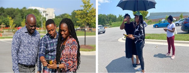
Left: Members of the workshop group test the customized ODK data collection form outside. Pictured (L to R) are: Kennedy Anahinga of the Ministry of Agriculture, Kenneth Mwangi of the International Centre for Precision Agriculture, and Diana Frimpong of UMD. Right: PI Dr. Catherine Nakalembe (left), UMD specialist Diana Frimpong (center), and Esther Maina of the Kenya Space Agency (right) conducted an impromptu field survey using the adapted ODK form.
This ECAAS project will continue through October 2023. Ahead of the national field campaign, the NASA Harvest team will travel to Kenya to hold a collaborative workshop engaging the Ministry of Agriculture and county extension teams.
In the short-term, the project aims to improve regional yield evaluations by expanding the sampling framework to Kenya and three other focus countries - Uganda, Tanzania, and Zambia. The data collection protocols and sampling frameworks can inform future efforts.
For sustained impact, the project is working closely with the Kenya Ministry of Agriculture to leverage their nationwide extension agent network for local data collection. This collaboration also aims to develop a scalable methodology for evaluating remote sensing-based yield models using field data.
In the long run, a robust dataset integrating satellite and ground observations could help the Ministry assess crop performance, benefit the Crop Insurance Programme, and validate other yield forecasting models.
Workshop participants provided positive feedback on the collaborative approach and hands-on nature of the training. They emphasized the value of engaging end users like the Ministry of Agriculture in project design to ensure adoption and sustainability. Developing local capacity and tools to improve agricultural data collection was another key theme. Participants looked forward to applying the skills gained to enhance crop monitoring, inform data-driven decisions, and ultimately strengthen food security in Kenya. Participants emphasized the value of co-designing projects with end users to ensure local buy-in, capacity building, and sustainability. They noted the potential for improved data to strengthen food security monitoring, planning, and policies. There was enthusiasm for integrated approaches leveraging Earth observation, machine learning, and field surveys to build comprehensive agricultural datasets.
"Projects designed with the users at the table go a long way in ensuring adoption and future improvement. This is how to advance impact in research and improve food security." Kenneth Mwangi, ICPAC
Ms. Jane Kioko, from the Food Crop Statistics, Ministry of Agriculture, emphasized the interactive nature of the workshop and the value of real-time data collection experience for officers. She highlighted new tools like Global Agricultural Monitoring System (GLAM) that can enhance reporting capabilities. Kioko also noted Kenya's openness to building capacity for agricultural monitoring and food security forecasting using Earth observation. While Mr. John Juma, also from MoA, highlighted the relevance of the workshop discussions for improving agricultural data collection, which has long posed a challenge. He noted that accurate, real-time data on crop yields enabled by machine learning and earth observation will be key to planning and decision-making for stronger food security.
"The workshop provided hands-on experience with valuable tools like Collect Earth Online (CEO), ODK, and OpenMapFlow. Building data analytics skills is a good start towards data-driven decisions to enhance agriculture resilience and food security in Kenya." Ms. Esther Maina, Kenya Space Agency
Kennedy Anahinga of the Crop Insurance Programme, Ministry of Agriculture, appreciated the practical training approach. He noted the project can provide timely crop performance data to enable early action and informed decisions. Anahinga emphasized that credible data is critical for agricultural insurance success and timely farmer compensation. He looked forward to continued collaboration.
"The hands-on training was well executed. Timely crop performance data enables early action and objective decisions. Access to quality data is key to expanding agricultural insurance and prompt farmer compensation." Kennedy Anahinga, Crop Insurance Programme, Ministry of Agriculture
Ms. Jane Kioko (Far Right) from the Kenya Ministry of Agriculture reviews the data collection protocol for the workshop group. Left-Mr. Peter Okello (KSA); Center-Ms. Taryn Devereux (UMD).